WebGL, Cesium, Unity and UE for Digital Twins: How to Choose
Choose Web 3D, Cesium, Unity, or UE according to the delivery path. Evaluate WebGL/Three.js for browser-based business 3D, Cesium for geospatial and wide-area maps, Unity when existing assets or cross-device 3D interaction matter, and UE for complex immersive scenes. Confirm target devices, where rendering occurs, data, and maintenance first, then validate on a representative scene. No approach is universally first choice.
On this page14 sections
WebGL, Cesium, Unity, and UE are not a simple ranking of high and low tiers. The goal is to match spatial presentation, business actions, access method, and operational constraints.
Three direct answers about digital twin technology selection
These address what each route offers, prerequisites, and prototype acceptance. A static visual is not a substitute for production conditions.
How should WebGL, Cesium, Unity, and UE be selected?
For custom 3D interactions in a browser, assess WebGL and Three.js. For geographic coordinates, terrain, imagery, and 3D Tiles at scale, assess CesiumJS. For high-quality real-time rendering and immersive interactions, assess UE5. With an existing Unity project, check whether assets and plugins can be reused and whether client or Web builds are feasible. These names describe different layers; compare concrete delivery paths, not a context-free ranking.
Which constraints must be confirmed first?
Confirm spatial extent, target devices, GIS and coordinate needs, model scale, concurrent users, network and GPU conditions, interaction depth, data refresh method, deployment environment, and ongoing maintenance ownership. Static screenshots cannot tell you whether a route will work in production.
Why validate with a small prototype first?
Use a representative scene, models, data, and target device. Measure first-load time, stable frame rate, object-location accuracy, image quality, bandwidth, concurrency, and operations steps. Confirm the route from those records, not one demo, a tool preference, or marketing claims.
Selection note: Third-party licenses, performance, and prices change by version. Use current vendor materials and actual tests for project decisions. See the content notes (Chinese) for more detail.
Understand the problem each technology solves
WebGL is a browser graphics capability. Projects often combine it with libraries such as Three.js to build campus, factory, equipment, and indoor or outdoor 3D interactions. CesiumJS is an open-source JavaScript library for browser-based geospatial visualization, useful for maps, terrain, imagery, coordinates, and large-area 3D Tiles. UE5 is a real-time 3D engine suited to high-quality materials, lighting, complex scenes, and immersive interactions. Browser delivery often means running the application on a server and streaming video and interactions via Pixel Streaming.
These technologies solve problems at different layers. Compare not just screenshots, but access methods, concurrent users, bandwidth, graphics hardware, data updates, and routine maintenance.
Core differences
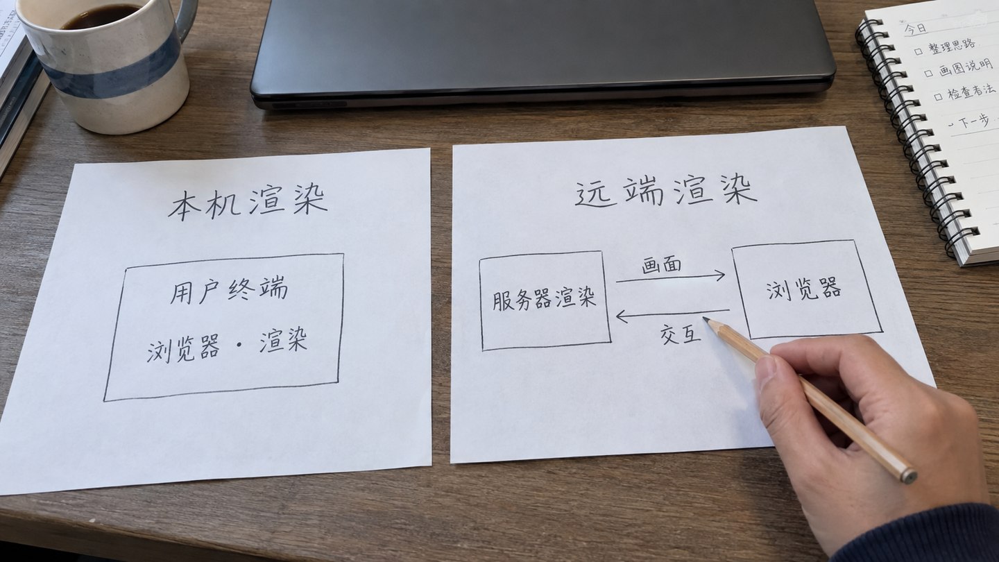
A browser entry point does not tell you where rendering happens. Web 3D or Unity Web may run 3D content on the user's device. UE Pixel Streaming renders on a remote machine and carries video and interactions over the network. The former requires client load and runtime testing; the latter also needs server, encoding, network, and session-capacity tests. The table compares concrete delivery paths.
The browser can show content rendered locally on the device or rendered remotely and streamed back with user input. Either way, validate target devices, servers, and network conditions.
Scroll horizontally to see the full comparison table.
Decision criterion
WebGL / Three.js
Cesium
Unity (client / Web)
UE5
Typical space
Campus, factory, equipment, floor, or showroom
City, watershed, utility network, roads, port, or large-area GIS
Existing Unity scene, equipment interaction, training display, or digital twin application
High-fidelity campus, factory, tunnel, exhibition, or immersive scene
Access method
Direct browser access
Direct browser access
Client application, or a Web build adapted to the target environment
Client application or server-based Pixel Streaming
Geospatial capability
Can be built, but coordinates and map functions need to be organized separately
Suited to terrain, imagery, coordinates, 3D Tiles, and wide-area spaces
Depends on map plugins, coordinates, and data pipeline; the engine name alone does not decide it
Can use GIS plugins or external services, with additional planning
Visual focus
Lightweight business interaction and Web integration
Wide-area space, maps, and geographic data
Existing 3D assets, scripted interaction, and target-platform runtime
Materials, lighting, immersion, and complex scene presentation
Server needs
Most rendering pressure falls on browser devices and Web services
Tile/data distribution, network, and browser device matter most
Client or Web device runs the scene; data services and asset delivery still need deployment
Pixel Streaming usually needs a GPU server capable of video encoding
Concurrency considerations
Closer to a typical Web app, but model and network resources still need limits
Tile, model, and imagery loading require careful control
Check resources and service requests per target device and define multi-user state synchronization
Check each local client; for Pixel Streaming, also size rendering sessions, encoding, bandwidth, and connection architecture
Business-system integration
Relatively straightforward to combine with forms, charts, permissions, and backend systems
Useful for a GIS page alongside business panels
Can communicate with business systems through APIs and Web scripts, but messaging, identity, and errors must be implemented
Often shares responsibilities with an external Web system rather than putting every workflow inside the 3D engine
When to consider WebGL or Three.js first
If most users access it through a browser and the tasks are equipment status, floor switching, model selection, metric charts, alert lists, and backend administration, Web 3D is often easier to connect to existing business systems. It suits campus, factory, equipment-maintenance, and showroom projects with defined model scope, multiple viewers, and ongoing page changes.
Validate polygon counts, texture sizes, initial load, low-spec devices, and browser compatibility. Browser access does not remove performance constraints. Model hierarchy, on-demand loading, asset compression, and point management remain core implementation tasks.
When to consider Cesium first
If real geographic coordinates are essential—for city lifelines, watersheds, roads and bridges, ports, campus groups, pipelines, or emergency resources—Cesium is a strong spatial foundation. It supports terrain, imagery, oblique photogrammetry, 3D Tiles, points, lines, polygons, and cross-region navigation.
A Cesium project still needs a business layer. Showing objects on a map does not solve alerts, work orders, permissions, statistics, or maintenance. Define separate responsibilities for the spatial base, data services, and business systems.
How to assess an existing Unity project or 3D interaction needs
With existing Unity scenes, models, C# interactions, or plugins, check first whether the assets open in their original version. Then decide whether the deliverable is a client or browser build and what adaptation is needed to continue the project. Unity offers a Web build path and Web-page script interaction. A working client does not mean plugins, APIs, and input methods will work in a Web build without changes.
Check browser support against the engine version. The Unity 6.0 browser compatibility documentation used here lists desktop and mobile conditions separately. Do not carry one version's support claims over to another or promise every phone and browser will work. Test loading, touch controls, memory, and full business interactions on actual target operating systems, browsers, and devices.
If high-quality materials, lighting, weather, complex equipment animation, immersive walkthroughs, simulations, or major exhibitions are truly required, UE5 is a candidate. Compare it with other approaches on the same representative scene and target device. Browser access usually adds a Pixel Streaming service, so evaluate GPU, video encoding, bandwidth, concurrent sessions, network traversal, and operations together.
UE5 should not own every form, approval, or backend configuration. A more workable division is often UE5 for spatial location and high-fidelity scenes, a Web system for lists, queries, permissions, work orders, statistics, and configuration, and data services supplying consistent object IDs and states to both.
When a hybrid architecture makes sense
Scroll horizontally to see the full comparison table.
Combination
Suitable project
Suggested division of work
Cesium + Web business system
Cities, utility networks, watersheds, roads, and cross-region projects
Cesium handles space and maps; Web handles metrics, events, permissions, and work orders
Three.js + data dashboard
Campuses, factories, equipment, and floor management
The 3D scene locates objects; charts and backend handle analysis and maintenance
UE5 + Web business system
High-fidelity campuses, tunnels, energy stations, and exhibitions
UE5 handles immersive scenes; Web handles long-term operating functions
Cesium + UE5
Projects needing both wide-area GIS and high-quality presentation of selected areas
First align coordinates and model pipelines, then choose entry points by user task
Eight questions to answer before choosing
Who are the main users: operations staff, executives, showroom visitors, or the public?
Is the spatial extent one device, building, campus, city, or watershed?
Are real coordinates, terrain, imagery, pipelines, or oblique photogrammetry required?
Is the visual goal clear status communication or immersive presentation with high-quality materials?
Will users access it through a browser, fixed workstation, phone, or showroom equipment?
How many concurrent users are expected, and what bandwidth and server GPU are available?
Which APIs, video sources, equipment points, alerts, and business workflows must connect?
Who will maintain models, object IDs, configuration, servers, and version updates after launch?
Prototype a small area before confirming the path
If the technology is uncertain, prototype one representative zone with a few real points, one alert flow, and a set of business metrics. Test loading time, clarity, response, browser or client runtime, weak-network behavior, concurrency, and maintenance steps. Expand model and data scope only after that evidence supports the route.
Scroll horizontally to see the full comparison table.
Decision dimension
Project fact or constraint
What to validate in a candidate route
Measured evidence
Decision conclusion
Space and coordinates
Spatial extent, coordinate system, terrain and imagery, model hierarchy, and update method
Can Web objects, Cesium geographic data, or UE scene coordinates map reliably?
Representative data loads, coordinate comparisons, and object-location records
Name the spatial base and owner of coordinate accuracy
Access and performance
Target device, browser or client, network conditions, and concurrency mode
Test first load, interactions, resource use, weak-network behavior, and recovery on actual devices
Environment inventory, test scripts, monitoring graphs, and result snapshots
Judge against project goals rather than generic frame-rate or user-count targets
Visuals and business
Materials, lighting, walkthrough, maps, charts, forms, permissions, and work orders
Test whether 3D rendering and business operations need to be implemented by the same technology
Prototype workflow, role tasks, feature comparison, and review record
Split responsibilities among rendering, business UI, and data services
Deployment and maintenance
Servers, GPU, encoding, bandwidth, licensing, model updates, and operators
Practice releases, session recovery, version upgrades, and asset replacement
Deployment topology, resource logs, recovery steps, and maintenance-effort records
Record why routes were adopted, combined, or excluded and who made the decision
What official sources can verify
Khronos WebGL official page confirms that WebGL is a low-level browser graphics API, not a full business framework.
Official feature descriptions do not replace project tests. Validate product versions, licenses, model pipelines, GPU and encoding capabilities, networks, concurrency, browser compatibility, and maintenance cost in the target environment.
Frequently asked questions
Are WebGL, Cesium, Unity, and UE products at the same layer?
No. WebGL is a browser graphics API; CesiumJS is a geospatial 3D library; Unity and Unreal Engine are real-time 3D development engines. Combine them according to space, target devices, existing projects, and deployment needs.
Must a campus digital twin use UE5?
No. If equipment states, operating metrics, and browser access for many users matter most, Web 3D may be a better fit. Prioritize UE5 only when high fidelity and immersive interaction deliver real value.
What works well for a city-scale GIS digital twin?
For cities, watersheds, pipelines, and large geographic areas, assess Cesium and 3D Tiles first. Add UE5 or a Web business system if the visual and interaction requirements call for it.
What should a digital twin technology decision confirm first?
Confirm users, spatial extent, GIS needs, visual goals, concurrent access, devices, servers, data APIs, and maintenance capacity. Then validate with a prototype.